Discover Hennepin County property insights quickly and accurately. Access city-specific zoning maps for Minneapolis, Bloomington, and Edina to understand property classifications and restrictions. Utilize the Hennepin County Property Information Search to check parcel details, assessment values, and tax information. Explore interactive GIS maps or request printed district and survey maps from the county. Stay informed, make smart property decisions, and simplify your real estate research with these tools.
Hennepin County offers a comprehensive suite of maps and geospatial data for property research, planning, and surveying. From city-specific zoning to district, foreclosure, and aerial photo maps, official tools and printed resources are available for professionals, investors, and residents. Digital downloads, printed maps, and custom database extracts ensure access to accurate and up-to-date property information.
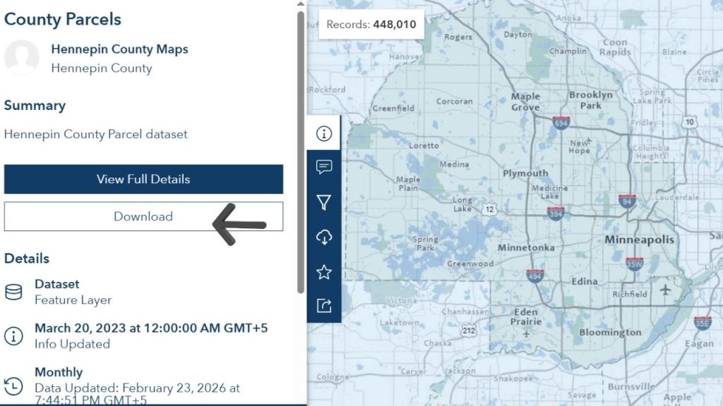
Free Hennepin County GIS Map Downloads
Access and download Hennepin County GIS maps for free, including interactive property, zoning, district, and environmental maps. Easily view parcels, tax data, and property boundaries online for research.
City and Property Maps
Hennepin County provides a variety of maps tailored for property research. These include:
- Property Maps – Black linework with color-enhanced details, available on white paper.
- Section Maps – Full sections or half/quarter sections in PDF format.
- Aerial Photo Maps – Color prints for areas outside Minneapolis, pre-2000.
- FEMA LOMA Maps – Access through Natural Resources application for flood map amendments.
Maps are available in digital downloads or printed on request, with high-gloss photographic paper at an additional cost.
Property Map Types and Pricing
Hennepin County offers multiple map types with clear cost structures:
| Map Type | Size / Format | Cost (USD) |
|---|---|---|
| Property Map | Letter (8.5” x 11”) | $4 |
| Property Map | Ledger (11” x 17”) | $5 |
| Property Map with Photo Overlay | Letter | $6 |
| Property Map with Photo Overlay | Ledger | $7 |
| Section Map | Ledger | $5 |
| Section Map | “D” size (24” x 36”) | $15 |
| Section Map with Photo Overlay | Ledger | $7 |
| Section Map with Photo Overlay | “D” size | $25 |
| Aerial Photo Maps | 20” x 30” | $20 |
Note: High-gloss or other specialty paper incurs extra charges. Prepayment is required for printed maps.
Ordering Printed Maps
To order printed maps, submit a mail request including the description of the desired map along with a check payable to Hennepin County Auditor:
Mailing Address:
County Surveyor Map Order
300 South 6th Street, A-703 Government Center
Minneapolis, MN 55487-0073
Additional Mailing Costs:
- $3 – Mailing tube
- $2 – Mailing envelope
Maps can also be purchased in person or over the phone:
- Phone: 612-348-3131
- In-person: 7th Floor, Hennepin County Government Center
District & Foreclosure Maps
Hennepin County provides current and historical district and foreclosure maps for download. These resources allow for property trend analysis and investment research.
| Map Type | Coverage | Cost |
|---|---|---|
| District Maps | Current 24” x 24” | $20 |
| Current Foreclosure Maps | 22” x 34” | $20 |
| Previous Foreclosure Maps | 2005 – Mar 2013 | $20 |
Digital versions are free through the Hennepin GIS portal.
Land Survey Resources
Professional survey resources and support include:
- County Surveyor Office: surveyor.maps@hennepin.us | 612-348-3131 | Fax: 612-348-2837
- MN Society of Professional Surveyors: FAQs on surveying standards
- Bing Maps: Tool to locate surveyors
- FEMA LOMA Maps: Accessible via Natural Resources application → Help → Flood Map Amendments
Database & Custom Extracts
Hennepin County offers GIS and geospatial data extracts for detailed analysis:
| Data Type | Fee | Details |
|---|---|---|
| Digital Ortho-imagery | $0.20 per acre | JPG, MrSID, or TIFF |
| 1/2 & 1/8 Section Maps – County-wide | $300 | PDF on CD |
| Individual 1/2 & 1/8 Section Maps | $0.20 each + labor | PDF on CD |
| Database Extract (Parcel Record) | $0.01 – $0.05 per record | Parcel graphic + attributes; requires signed user agreement |
| Entire Database Extract | $4,000 | Initial cost; quarterly updates $300/quarter |
| Geocoded Street Centerline File | $3,000 | Initial cost |
Extraction Transfer Media: $2 per CD/DVD + $50/hour labor.
Plotting Fees
Printing maps in different formats has set rates:
| Type | Fee | Details |
|---|---|---|
| Linework Only | $8 per linear foot | $45 minimum |
| Digital Ortho Only | $8 per linear foot | $45 minimum |
| Linework + Digital Ortho | $15 per linear foot | $60 minimum |
| High-Gloss Paper | Additional $3 per linear foot | $10 minimum/item |
Prepayment is required for plotting and map purchases.
Conclusion
Hennepin County ensures that property data, maps, and GIS resources are accessible, accurate, and professionally maintained. Whether for property research, surveying, or investment, official digital downloads, printed maps, and database extracts provide all necessary tools. Clear pricing, prepayment procedures, and multiple access points simplify map acquisition and make Hennepin County a reliable source for property information in Minnesota.
FAQs
How can I use Hennepin County GIS property search to find parcel and tax details?
Access the Hennepin County GIS property search to view parcel boundaries, property values, assessment data, and interactive map features for accurate property research.
How do I download the Hennepin County interactive property map PDF?
Visit the official Hennepin County GIS portal to download interactive property map PDFs showing parcel details, zoning, and property boundaries.
What information does the Hennepin County Natural Resources map provide?
The Hennepin County Natural Resources map shows flood zones, wetlands, parks, and environmental features for planning and land management purposes.
How can I use the Minneapolis GIS map for property research?
Minneapolis GIS maps provide interactive city zoning, parcel boundaries, and land use information for property analysis and real estate planning.
What is the Hennepin County interactive property tax map?
This map displays parcel-specific tax data, assessment values, and interactive layers to help property owners and investors monitor taxes accurately.
How do I download Hennepin County GIS maps?
Users can download Hennepin County GIS maps in PDF or interactive formats through the official GIS portal, including district, property, and environmental maps.